

You must log in or register to comment.
Reasoning from their FAQ:
Will Magic Earth be Open Source?
No; since it is also used commercially (we have a paid Magic Earth SDK for business partners), we cannot make the code public.
Only reasonable option!
inb4 organic maps. Yeah buddy sure, I love being told I’m turning right off the freeway in 1.3 miles instead of just the exit number.
I’ll gladly give it a try, but I have a question…
How to this company make money?
There are no ads, and they claim to not sell my info, yet they appear to have the funds to make a nice app with a lot of interesting features, how to they accomplish this?
Right I have taken a test drive with the app, without navigation but having the map up, and there are a few things I dislike.
I hate audio warnings, I use navigation apps as a complement to driving, like they say in avaiation “aviate, communicate, navigate”, any automatic warnings tend to just distract me.
Ok so, sound was disabled, on to location accuracy.
Good when on a road, but I turned on to a parking lot and it refused to acknowledge that I had left the road, so road snapping is set too high
Ok, what about the map itself, the design of it?
The map looks great!
But the 3D view is set at a too shallow of an angle and shows me the horizon, that is just distracting to me, and I could not find a way to change it.
Ok, what about the UI?
Nice, I like it apart from the speed display on the map overlay.
It is too distracting, and I don’t like that it shows your speed in bright red as soon as you go 1kmh over the limit.
Ok, what about the data?
It is unforutnately outdated or just wrong in the area I drove in.
Sadly I will probably be going back to google maps.
Good question. I think it’s basically a demo app for their location based libraries you’d use to build like a custom ambulance service routing solution.
I hate audio warnings
I’m a little confused. You said you didn’t use navigation. What kind of warnings would it give you when not navigating?
It is too distracting, and I don’t like that it shows your speed in bright red as soon as you go 1kmh over the limit.
Is it notably more distracting than the speed display Google has? That turns red when you’re over the limit, but I’ve never really noticed it except when looking at it.
what about the data?
According to other comments, these guys apparently just use OSM. So this is something you could definitely help fix yourself. Though I appreciate if it’s more than a small handful of errors that would be too much of a task.
Sadly I will probably be going back to google maps.
Yeah that was unfortunately my experience last time I tried an alternative mapping application. Organic Maps, I tried, on recommendation of some Lemmy users. But search in Organic Maps is literally unusable. You can’t always search for full addresses, only street names (I can put in numbers on some addresses, but not mine, apparently), and even that is useless because the results list contains “street name”, “city”, and “state”. It doesn’t tell you suburb. Which means if there are multiple streets in the same city with the same name (which, at least in my city, happens all the time), you have no way of knowing if you’ve clicked on the right street. It also required me to turn off “avoid tolls”, because it incorrectly reports one of the best routes I regularly take as being a toll road because if you go straight at this one intersection where I turn right, then you would be on a toll road.
Add to that the loss of things like location history and crowdsourced realtime traffic data, and it quickly becomes too big of a trade-off.
It’s unfortunate because I want to be able to support FOSS and get my data away from Google. But like you’ve just experienced with Magic Earth, I just find the competition isn’t good enough to actually use.
It warned me about something called “static camera” or similar, where there are none.
It also warned me about my speed being too high, at that time it was accurate, but later I saw the speedlimit display show the wrong information.
The speedometer is more prominantly displayed in Magic than in Google Maps, it shows on a dark black background while Google maps has their speed info so that it blends into the background, making it less distracting, also Maps shows it only when I am actively navigating, Magic shows it constantly.
something called “static camera”
What they mean by that (whether it’s accurate or not is another question) is a speed camera or a red light camera that’s located in a fixed spot, as opposed to a mobile speed camera that might be pointed out the back of a police van, or handheld by a cop standing on the side of the road.
I suspected as much, but in the decade I have been living here, there has never been a camera in that area…
The have a paid sdk for businesses, not for endusers, Magic Earth is just a byproduct.
Magic Earth is free for all our end-users but we also have a paid Magic Earth SDK for business partners. For instance Selectric.de (a supplier for navigation solutions for ambulances and fire trucks), Smarter AI (developing ADAS systems) or Absolute Cycling (using the platform on bicycles). For more info on the SDK, you can check magiclane.com.
They also collect anonimized traffic data from users:
We send position data to our traffic provider to generate real-time traffic information. The data is anonymized on the phone, using a changing key (so it’s not linked to you), and it is deleted after 5 minutes.
Both info is from their faq: https://www.magicearth.com/faq-en/
Why is 3/5 of the screen not the map? You know, the primary function of a map.
Android Auto will let you split-screen, it looks something like this. Carplay might be similar?
Yeah, if you select or tap the map portion, it expands to full screen.
Android Auto will let you split-screen
On my phone it used to have a really small media control at the bottom so I could skip forward in my podcast or pause. For some reason the last two or three weeks that hasn’t worked any more. It’s so frustrating.
It’s specific Apple CarPlay mode, if you click on your map app you will see it full.
UI is kind of cartoonish too
Looks like Android auto
I’m a fan, although I’m not sure it’s a great name. It helps keeps my motivation for updating OSM going.
Why? What are the benefits? Better than Waze too?
Waze is owned by Google, so it probably implemented the “Gulf of America” typo too. Just tested Magic Earth for a few minutes, and Organic Maps seems to be the more polished of the two in terms of OpenStreetMap frontend apps, in my opinion.
HERE WeGo is really good, I’ve been using it for years. Has offline mode too so you only rely on GPS and downloaded maps, but has online mode too for realtime traffic info. Can’t comment on this part since I don’t use it.
I tested Magic Earth for my work commute for about a week in hopes of moving away from Waze. It is working really well, but what it really lacks is information about traffic congestion. It will always take me though the same route to work and set a really optimistic ETA because it assumes low traffic. The main benefit of waze is anticipating traffic and planning reroutes. With Waze my ETAs have always been surprisingly accurate, but Magic Earth was off by almost 20 minutes on a 1 hour commute and placing me in the peak traffic route
Yeah this is a key feature for me so won’t be switching from waze
OSM frontend.
there’s no totally FOSS maps app on IOS, but a free OSM frontend is about as good as you’re going to get.
Thanks for the recommendation, was trying out organic maps and it was lacking allot. This seems promising as a replacement.
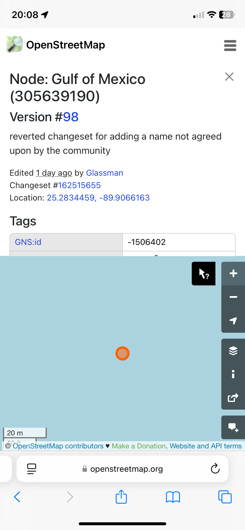
Does it show the Gulf of America?
It uses OSM mapping which is publicly edited, currently it is showing Gulf of Mexico as of 1 day ago when they reverted some morons edit.
It doesn’t label areas of water.
Yeah, love the dashcam function. But when there are roads temporary closed, i switch to waze. But magic earth is my standard gps.
Was kind of joking but it’s nice to know.


