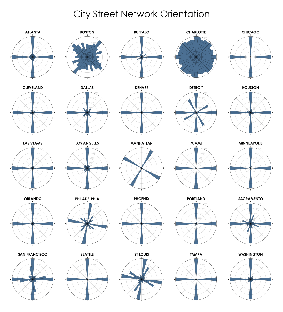
Yeah, I think it’s something you see in any city built in the last several hundred years that’s near water and engaged it maritime transport. Recent enough that we discovered that the grid system makes sense and simplifies things, and near water which gives one rational orientation for the grid, coast aligned centered around the port, ripe to conflict with the other “north south” sensible alignment.
If you look at Detroits roads, it’s got three grids, one north-south, one aligned to one part of the coast, and another smaller one aligned to a different part of the coast. It’s also fun because you can still see the faint remnants of when the roads were a radial spoke system built around the original french fort that caused the city.
Manhattan never gets far enough from the coast to switch.
It makes me wonder about cities with notable rivers built after the grid system. Do they align to the river, or just build bridges and pretend it’s not there?
Minneapolis uses the grid and is built along the Mississippi. In large part, the road closest to the river follows it, intersecting the grid. And a good number of the grid roads use bridges.
Yeah, it looks like the bigger roads get a lot more latitude to wiggle around funny,xand the smaller ones seem to be chunked out in grids of at least a few blocks.
I honestly expected more cases of the grid just trying to ignore the river. It looks like the bridges usually cut straight across the river rather than at an angle.
I wonder if the price of increasing the bridge span isn’t worth the consistency it adds to the grid.

Yeah, I think it’s something you see in any city built in the last several hundred years that’s near water and engaged it maritime transport. Recent enough that we discovered that the grid system makes sense and simplifies things, and near water which gives one rational orientation for the grid, coast aligned centered around the port, ripe to conflict with the other “north south” sensible alignment.
If you look at Detroits roads, it’s got three grids, one north-south, one aligned to one part of the coast, and another smaller one aligned to a different part of the coast. It’s also fun because you can still see the faint remnants of when the roads were a radial spoke system built around the original french fort that caused the city.
Manhattan never gets far enough from the coast to switch.
It makes me wonder about cities with notable rivers built after the grid system. Do they align to the river, or just build bridges and pretend it’s not there?
Minneapolis uses the grid and is built along the Mississippi. In large part, the road closest to the river follows it, intersecting the grid. And a good number of the grid roads use bridges.
Neat!
Yeah, it looks like the bigger roads get a lot more latitude to wiggle around funny,xand the smaller ones seem to be chunked out in grids of at least a few blocks.
I honestly expected more cases of the grid just trying to ignore the river. It looks like the bridges usually cut straight across the river rather than at an angle.
I wonder if the price of increasing the bridge span isn’t worth the consistency it adds to the grid.