
West Side of Upper Gediz Vallis, From Tungsten Hills to the Next Rocky Waypoint - Curiosity Rover Blog for Sols 4302-4303
Earth planning date: Wednesday, Sept. 11, 2024
The rover is on its way from the Tungsten Hills site to the next priority site for Gediz Vallis channel exploration, in which we plan to get in close enough for arm science to one of the numerous large dark-toned “float” blocks in the channel and also to one of the light-toned slabs. We have seen some dark blocks in the channel that seem to be related to the Stimson formation material that the rover encountered earlier in the mission, but some seem like they could be something different. We don’t think any of them originated in the channel so they have to come from somewhere higher up that the rover hasn’t been, and we’re interested in how they were transported down into the channel.
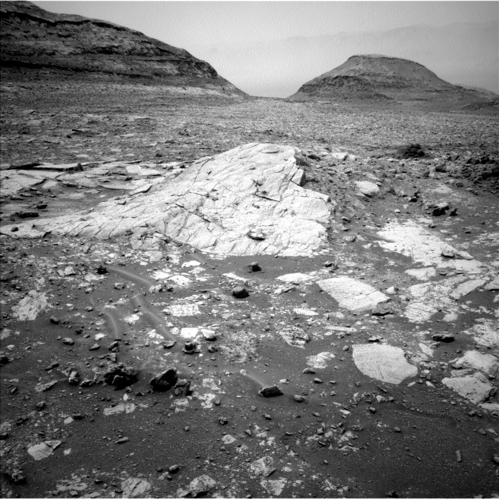
We aren’t there yet, but the 4302-4303 plan’s activities include some important longer-range characterization of the dark-toned and light-toned materials via imaging. Context for the future close-up science on the dark-toned blocks will be provided by the Mastcam mosaics named “Bakeoven Meadow” and “Balloon Dome.” The broad Balloon Dome mosaic also covers a low dome-like structure formed by the light-toned slab-like rocks (pictured). Smaller mosaics will cover a pair of targets that include contacts where other types of light-toned and dark-toned material occur next to each other in the same block: “Rattlesnake Creek” which appears to be in place, and “Casa Diablo Hot Springs,” which is a float.
The rover’s arm workspace provided an opportunity for present-day aeolian science on the sandy-looking ripple, Sandy Meadow. Mastcam stereo imaging will document the shape of the ripple, while a suite of high-resolution MAHLI images will tell us something about the particle size of the grains in it. The modern environment will also be monitored via a suprahorizon observation, a dust devil survey, and imaging of the rover deck to look for dust movement.
The workspace included small examples of the dark float blocks, so the composition of one of them will be measured by both APXS and ChemCam LIBS as targets “Lucy’s Foot Pass” and “Colt Lake” respectively.
In the meantime, the Mastcam Boneyard Meadow mosaic will provide a look back at the Tungsten Hills dark rippled block along its bedding plane to try to narrow down the origin of the ripples and the potential roles of water vs. wind in their formation.
Communication remains a challenge for the rover in this location. During planning, the rover’s drive was shifted from the second sol to the first sol in order to increase the downlink data volume available for the post-drive imaging, thereby enabling better planning at the science waypoint we expect to reach in the weekend plan. However, maintaining communications will require the rover to end its drive in a narrow range of orientations, which could make approaching our next science target a bit tricky. We’ll find out on Friday!
Written by: Lucy Lim, Planetary Scientist at NASA Goddard Space Flight Center Edited by: Abigail Fraeman, Planetary Geologist at NASA-JPL
Source for this blog and the archive of all blogs (with all the links and the original raw images etc): https://science.nasa.gov/blog/sols-4302-4303-west-side-of-upper-gediz-vallis-from-tungsten-hills-to-the-next-rocky-waypoint/
These blog updates are provided by self-selected Mars Science Laboratory mission team members who love to share what Curiosity is doing with the public.
Dates of planned rover activities described in these reports are subject to change due to a variety of factors related to the Martian environment, communication relays and rover status.
Image credits: NASA/JPL-Caltech
Are they named “Tungsten Hills” for their chemical composition, or some other reason?
It’s a naming convention.
Curiosity is currently in the “Bishop” map quadrangle. “Tungsten Hills” rocks, were named after a famous mining district near Bishop, California.
It was mentioned in this mission update https://science.nasa.gov/blog/sols-4300-4301-rippled-pages/
Before touching down in Gale crater Curiosity’s landing ellipse and the foothills of Aeolis Mons (Mt. Sharp) were divided up into 151 map quadrangles to aid geological mapping. Each of these square areas of interest spans 0.025 degrees in latitude by 0.025 degrees in longitude, each quadrangle measures about 1.5 kilometers square or about 1.22 x 1.22 km. Each quadrangle is assigned a name of a town with a population less than 100,000 people.
Map quadrangles are usually named after towns close to notable regions of geological interest on Earth, its name then provides the source of the target names within each quadrangle.
List of Quadrangles the rover has visited:-
Yellowknife: Quadrangle #51: Yellowknife a city in northwestern Canada as well as group of rocks from the same region. The rocks were formed 2.7 billion years ago from both volcanoes and sediments laid down by water, and were deposited over 4-billion-year-old rocks, the oldest known on Earth.
Mawson: Quadrangle #65: Mawson, Antarctica, permanent base and research outpost in Antarctica, named after the Antarctic geologist and explorer Sir Douglas Mawson.
Coeymans: Quadrangle #64. Takes its name from the town of Coeymans in upstate New York, located near the fossil‐rich Coeymans Limestone Formation.
Kimberley: Quadrangle #78. Takes its name from the northernmost region of Western Australia, the site of many important geologic investigations of Precambrian rocks.
Hanover: Quadrangle #77, Takes its names from a New Hampshire city.
Shoshone: Quadrangle #91. Takes its name from Shoshone Village in Inyo County, California located just outside Death Valley National Park and the Nopah Range Wilderness Area.
Arlee: Quadrangle #90. Takes is name from after a geological district in Montana
Windhoek: Quadrangle #104. Takes its name from a geological district in Namibia.
Bar Harbor: Quadrangle #118 Takes its name from Bar Harbor, Maine
Kuruman: Quadrangle #132. This quadrangle is named after a charming town situated on the edge of the Kalahari desert in South Africa. Notably, the town of Kuruman is the namesake for the Kuruman Iron Formation, a ~2.46 billion year sedimentary rock that is rich in hematite. Hematite is the same mineral we can see is distributed throughout the Vera Rubin Ridge from orbital data! The target names in this quadrangle are pulled from famous geological features from South Africa and nearby Botswana and Zimbabwe.
Biwabik: Quadrangle #119, the Biwabik name was selected because of the city’s connection with the Mesabi Range, which contains large deposits of Precambrian iron ore.
Torridon: Quadrangle #133, Named after a village in the Northwest Highlands of Scotland, which is near an important geological formation called the Torridonian Supergroup. Therefore, all of the names assigned to targets in this region of Curiosity’s traverse come from landforms, geologic formations, and towns in that part of Scotland.
Nontron: Quadrangle #134, ‘Nontron’ is named after a commune in the Dordogne in southwestern France. The Nontron quadrant name is particularly appropriate for the clay-bearing terrain we find ourselves in as Nontron is the type locality for a clay mineral called nontronite. Nontronite is part of the smectite group of clays, which are the most common types of clays on Mars.
Roraima: Quadrangle #147. The Roraima quadrant is named after the northern-most state of Brazil and Mount Roraima, which is the highest peak in the Pakaraima mountains which sits between Brazil, Venezuela, and Guyana. The terrain in the Roraima region on Earth looks somewhat similar to the area Curiosity is in - with flat-topped hills and some steep slopes.
Kalavryta: Quadrangle #148 Kalavryta is named after a town in Greece, due west of Athens and near the Chelmos-Vouraikos UNESCO Global Geopark, a region that consists of 40 unique geological sites including caves, karstic springs, rivers, alpine lakes, and fossil sites.
Bishop: (Current Quadrangle) Bishop California is located in Owens Valley, and is the starting point for trips into the High Sierra, including some awesome geology. It feels like a fitting name for this part of Curiosity’s ascent of Mt. Sharp!-
Cool! Thanks for the info dump!
I wonder if we’ll use these names when colonizing Mars. Like Earth has New York, New Jersey, and New Zealand, I wonder if Mars will eventually have human settlements at New Yellowknife, New Kalavryta, and so on.
I would hope they do a mix of “old world” and ‘new’ world names 😁
The dump is a text file i’ve updated as the mission progressed. Saves me time when I get asked the question re place names.