
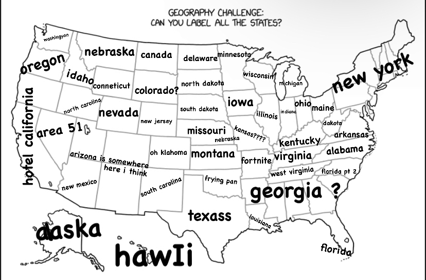
Alt text: Even with a blank map, a lot of people can only name 45-50 of the 64 states.
Tennessee and Elevenessee
Ninessee pronounced Nanci
I was expecting this one to be interactive but then I noticed the alt text. I’m not a geography nerd who’s going to explain this one
The map looks correct at first glance, but he’s added another 14 states by drawing the borders wrong XD
Not American, but I assume it’s wrong in some subtle and hilarious way?
deleted by creator
I just moved out of Kentucky and was like wait, there’s two Tennessee?
Tennessee and Elevennessee
spoiler
Yeah, he’s got Minnesota in there but totally left out Megasota
Two Tennessees, but no nineessee
Texoklahoma is up by Midsouthdakota?
North-West Virginia isn’t even a thing no matter what those weirdos say
The weird strip of land in the Great Lake
Removed Whodaho and added “Idaho”? WTF is Idaho?
It’s got the state we all agreed doesn’t exist?
And where is Mickeysota?
deleted by creator
deleted by creator
Bunch of extra states with similar shapes to existing states, so it messes with your eye and kinda blends in.
Might be harder to do with a map of Africa, Asia, Europe or south America because there aren’t as many straight line borders and things are a bit more curvy.
Working from the bottom left… California, Arizona, New Mexico… Wtf?
California, Arizona, New Mexico, Old Mexico, Texas …
I see what you mean about this map being anomalous. Some of the states seem to be doubled, I wondered where they got that 64 states figure from!! My bad!
Ah yes the great states of Arkansas and Arkan’tsas, of Kansas and Kan’tsas.
I’ve got: Neo Hampshire, Middle Carolina, Outdianna, Tennetucky, Rkansas, Northwest Dakota, West South Dakota, Souther Dakota, The Real South Dakota, Coloradon’t, Becausoming, Ariz Oh No!, Udaho & Trail
What’s interesting are the states you can’t modify too much or it gives away the game.
Texas is a key example, people are pretty familiar with that shape, even many non-Americans will recognize it. Florida and California are also pretty well known. Also, many people have a rough idea of NY State, though you could probably tweak the north and west borders a bit and nobody would notice too much.
The ones it’s easy to fiddle with are the rectangular ones in the mid-west. I think a lot of people only know them starting from another reference point, like “north of Texas” or “east of Nevada”.
A couple of my friends had a go at this one:
Some notable quotes:
“Wrong. It goes washingyon, oregon, gravity falls, hotel california”
“pennywise AND ohio, rough spot for maine”
“New Hampsire is not a state. I haven’t heard shit from someone in New Hampshire”
Texas, California, Colorado, Wyoming, Colorado again-… wait a minute
I don’t know if that’s West Ohio or East Indiana, but either way, it is a crime against nature
An Ohio without Columbus is an Ohio I want to be a part of.
We’re always as war with East
AsiaIndiana.
I like Central Carolina and Kennesaw.
My favorite is asking people what the 51st state is, Hawaii or Alaska?
How many states are in New Mexico?
Finally Center Dakotans have their own state! Justice after all!
Canadian here, from the outside it seems to just be 3 states. Almost crazy, crazy and don’t come here if you want to exist.
Ah yes, Washington, Oregon, Orecan’t, and California!
Removed by mod
Glad Jefferson got included.
East Maine is so much better than West Maine.
Is that west maine? I thought it was old hampshire