
- cross-posted to:
- [email protected]
- cross-posted to:
- [email protected]
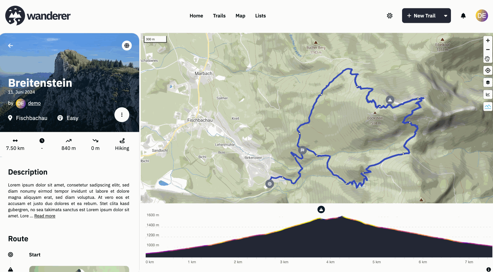
Hey everyone, #What is wanderer? wanderer is a self-hosted GPS track database. You can upload your recorded GPS tracks or create new ones and add various metadata to build an easily searchable catalogue. Think of it as a fully FOSS alternative to sites like alltrails, komoot or strava. #What is new? I’m coming back here to tell you a bit about what has been happening since my last update. Since then, we implemented some highly requested features:
- A fancy new 3D model on the front page (there is an easter egg, can you find it?)
- wanderer now uses vector map tiles which results in a significant performance boost for everything map-related
- As a result, we now also support topographical 3D maps in wanderer (see gif)
- Greatly improved social features: from list sharing, over profile pages and activity feeds to notifications
- The better location search allows you to search right down to the address
- And finally probably the most requested feature: integrations. You can now sync all your trails from strava and komoot directly with wanderer without having to manually export/import them
Big thanks to everyone who contributed code or translations! If you have any suggestions/questions feel free to let me know below.
Have a great weekend!
Flomp
- Github repo: https://github.com/Flomp/wanderer
- BuyMeACoffee: https://buymeacoffee.com/wanderertrails
- Docs: https://wanderer.to
- Demo: https://demo.wanderer.to
You must log in or register to comment.
I finally figured out how to get the terrain stuff going on my Wanderer. Super cool!
Now I’m trying to figure out my future workflow… can you shed some light on it?
Currently everything I upload is its own “Trail”. This goes for the Strava integration, as well as me just uploading a GPS track.
Trails are nice because they all show up on the Map, making a cool overview of everything I’ve done. Obviously over time this might bog down the system when viewing the map.
Trails aren’t included in the statistics, which is a bummer.
So, I played around with moving each of my activities into broader “trails”, based on where the activity took place. I think that’s probably how Wanderer is supposed to be used, because when I move activities from being a “Trail” to being a “Summit”, they are counted in the statistics.
The only downside to that is they don’t appear on the map, unless you click the specific Summit.
So, basically, my question is – should I just accept the fact that I should move everything into being a Summit, so I can enjoy the statistics?
Thanks!
When I first stumbled upon this I was wondering how a one person open source project can look this beautiful. Now I am also wondering how it can be so feature rich. Seriously, I just love this project. Sadly I have no use for it right now (not big into sharing my trails, nor know enough people for it to be used), but still wanted to leave a comment just for appreciating your effort and the result. Such a beautiful project.
Thank you very much! Really appreciate the kind words :)
Pocketbase does a lot of the heavy lifting, but yes it is a very nice project.
This means there are still nice things happening in the world.
Wow, sounds like a big update. Integrations sounds super cool and should really help with the workflow part of things.
Will the Strava integration create new trails every time or is it possible to have it create new entries to the summit book?
Speaking of which, is Summit Book the best name for that function? It took me a while to figure out what that was about.
Currently, it creates a new trail every time. I agree that the name is a bit unfortunate. It was fitting when wanderer started out because back then it was solely made for hiking. I plan to transform summit logs into leaderboards similar to strava in a future update. Then I will probably also rename the summit logs to something more fitting.
I want to try this. I’m one of the unfortunate victims of Gaia GPS turning to trash.
However, I can’t seem to find in the docs how tracks can be recorded…
Is there an app?
Do I need to be in contact with the server to record a track?
Do I need to ask my friends to send me gpx exports if they aren’t on strava?
Do you envision an integration with opentrailmap so in can share trails without having to expose Wanderer to public?
Recording is currently not possible with wanderer itself. I personally use osmAnd to record my trails and import them into wanderer. If you don’t want to expose wanderer to the public your friends would need to send you their trails, yes. But I guess that’s no different with any other service.
So I went to the demo and I have a few questions:
- Couldn’t figure out how to use 3d in demo (not critical)
- developer discord link on github is expired
- distinction between “public” and “shared” trails isn’t clear
- “Completion Status” for trails… what does this mean?
- Couldn’t import a trail in demo:
haystack-mountain-101522-105940.gpx
{"message":"TypeError: Cannot read properties of null (reading 'id')"}
I am actually really impressed with what you have so far, and I’d love to start using this!
- There is a mountain symbol on the map. Press it to activate the terrain. Drag the compass needle to tilt the map
- Thanks, fixed,
- A public trail is visible to everyone, including non-registered users. A shared trail is only visible (or editable) for the users you share the trail with
- If you add a summit log to a trail it is considered “completed”
- Can you provide a full error stack trace, please?
There’s also a more lightweight alternative for recording tracks called OpenTracks. It can export the data in KMZ, KML, GPX or CSV format.
Ok, I think I can deal with recording on an OSM client. I’ll give Wanderer a try.
You might want to check out https://gpslogger.app/ for logging. I’m super happy with the battery usage. My use case is on multiday tracks, so battery charge is a luxury.
I have no use for this. Yet. I’m very happy it exists and I’m playing with it now.
This is really neat. I’ll be trying it out for sure
No way to login with a fediverse account ? ;-)
Does it integrate with Garmin as well?
Unfortunately Garmin does not offer their API to private consumers: https://developer.garmin.com/gc-developer-program/program-faq/
I have not found a way to pull the data without API access.
They do, check fittrackee they have a python sync to garmin, I use it
Thanks, I found it: https://git.dryusdan.fr/Dryusdan/garmin-to-fittrackee
I’ll check it out!
I read below that you activate the 3D terrain using the mountain icon, but I still can’t get it to work with Firefox. I’ve tried the demo site with the same results. Is it maybe some sort of proprietary Google thing?
Edit: I see now in the docs that I need to point it at my own terrain data. I’ll look into that.
Have a look at the demo site. Everything is set up there already. I personally use the generous free tier of MapTiler.
I’m a fan of Wander, and have followed these posts with great interest, but haven’t been able to successfully install it get myself. I’ll give it another try in late Feb early Mar.


