Rules:
- You could add or remove states.
Outcomes:
- What impact would the new borders have?
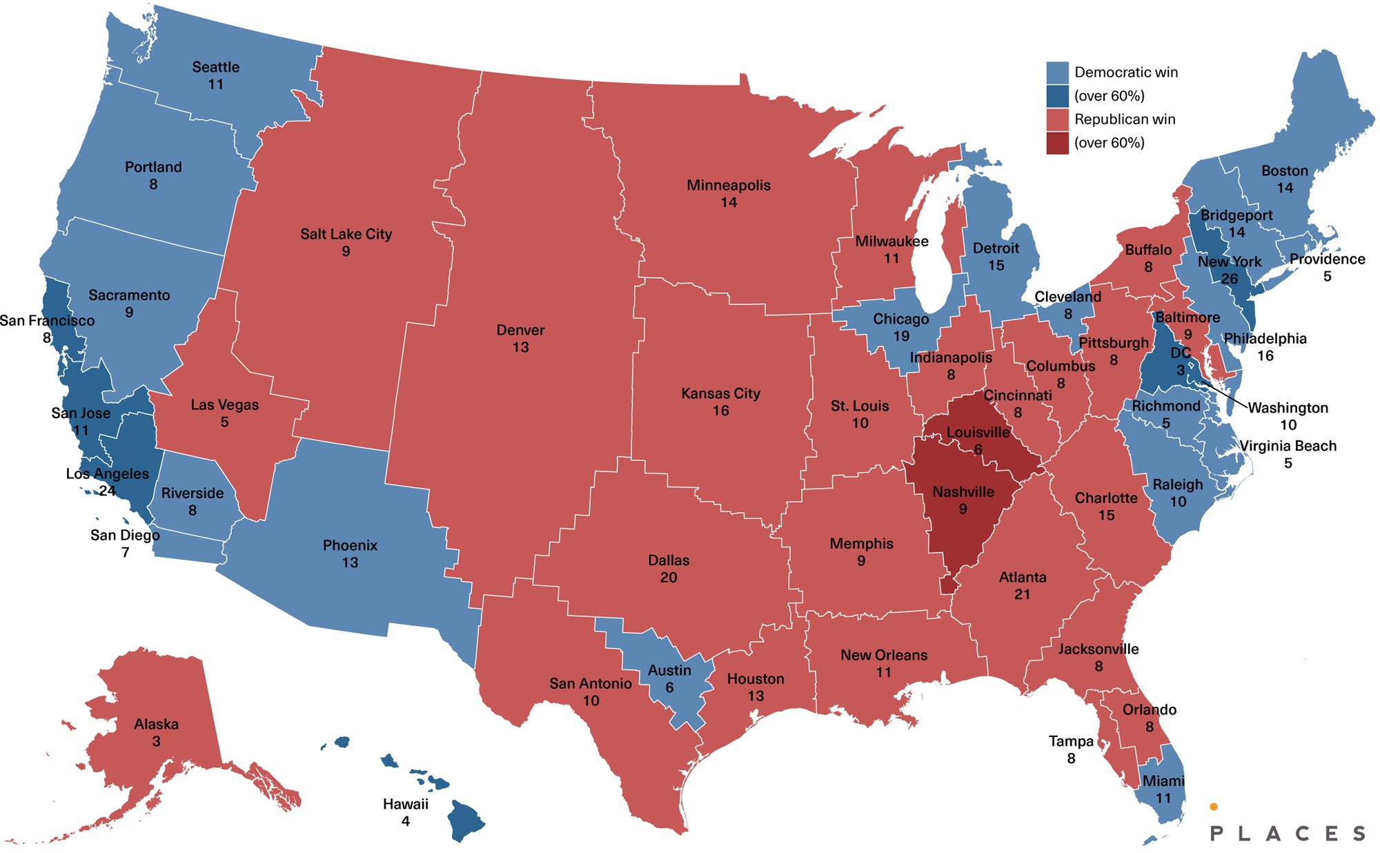
Voronoi partitions around major cities. States would be very angular, but the logic is simple.
The hard part is deciding the criteria for what constitutes a major city. Some places are easy: cities like Las Vegas or Kansas City don’t have any large, competing population centers nearby. But would Sacramento be considered a major city, or would it be under San Francisco’s umbrella?
Some small cities like Fargo or Bismarck are still significant population centers relative to their regions. Would they be independent or fall within the state of a larger but very distant city like Minneapolis?
One could use population as the generator weight.
Perhaps for all incorporated cities/towns/whatever then do a higher order application to group those.
This attempt actually looks half-decent. Though northern Idaho is going to lose its mind having to be governed by Seattle.
Stolen from the site formerly known at Twitter: https://x.com/StatisticUrban/status/1828623681322655800
I like the chicago teapot but seems wierd detroit has part of the penisula and then milwaukee has part across the lake.
They should trade that blue tip of the UP to Milwaukee, and in exchange Detroit gets all of the mitten.
I think the thing is that there are a bunch of summer homes on that side of the lake but the tip of the penisula has a very low population. Thats my guess anyway. Still if thats the case you would still thing milwaukee would get the whole penisula and the bite they take out of the mitten would be made smaller.
You’d definitely have to answer some questions like “How many states do we want?”, but Fargo/Bismarck would just become the centers of counties if they don’t make the cut for being separate states.
Beat me to it!
Oooh that’s neat. Using the Manhattan distance makes for a slightly nicer set of borders.
Merge all states into Minnesota. Tim Walz is now effectively president. The world is saved.
All states would have their boarders end at rivers or mountain ranges. This includes states that border other countries, we just conceed what we need to match a natural boundary. All waterways that are between states become federal waterways, overseen by the national parks department.
There will be chaos, and it will be glorious. No more states screwing the states that are downriver though, so that’s a win. .
Combine North and South Dakota, resplit into East and West Lakota.
That’s the most important change.
where’s the best state proposal of all?

Did a quick search and could not find it but some guy in the past. Im thinking this was like lewis and clark times. He suggested a few states drawnup by watertable which would avoid some issues with water we have today.
A watershed map could make sense. It’s basically another way of dividing by mountain ranges and rivers. I like that you don’t need to redraw borders as people move and populations change.

Source: https://www.usgs.gov/media/images/watershed-map-north-america
Ah, I’d remove them.
No pls. Don’t ruin my state.
Puerto Rico becomes a state.
Kansas City belongs in Kansas.
Florida is ejected from the US. Highest bidder, independence, whatever.
Give Florida to Cuba, then grab a truckload of popcorn and watch the political fallout.
No way that could happen.
But maybe if we sweeten the deal, and throw in like $50 they’d take it then?
I would do something minor to mess with the four corners intersection. Mua ha ha ha!
Each state boarder is low density farm fields, pastures, and deserts. No boarders with houses tight to the line. At lease 100 feet on both sides (200 feet total).
Then size states by population. ~20 million in each state.
Places with super low density are no longer states, but territories. Maybe less than 1 person per square mile within a 10 mile radius. (For all such 10 mile radiuses.) More than that within the radius, then part of a state.
Given the current state of things, no pun intended, I would give Alaska back to Canada. Not sure what to do with Hawaii. Maybe give the residents a vote to remain a state, become an independent nation, or go for something in between like Puerto Rico.