
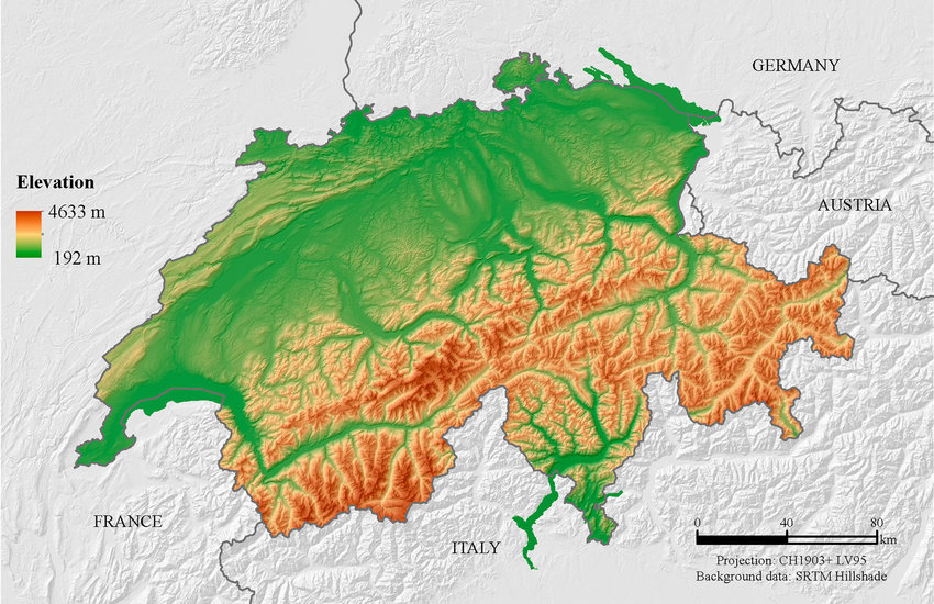
For example on wikipedia for Switzerland it says the country has an area of 41,285 km². Does this take into account that a lot of that area is actually angled at a steep inclination, thus the actual surface area is in effect larger than what you would expect when looking onto a map in satellite view?
You must log in or register to comment.
I can’t remember if it was Matt Parker or Tom Scott who did a thing about this on youtube, and I think the answer was no, they just use whatever method is easiest to get these numbers, and they’re not even using a consistent methodology from one country to the next.
It was by Matt Parker. Here it is: https://youtu.be/PtKhbbcc1Rc
or watch it on piped.video if you prefer: https://piped.video/PtKhbbcc1Rc
Holy fucking shit. I can’t believe this is a question people have asked and others have answered and that the answer is so unsatisfying for pedants.
thanks for the links!
I can’t remember if it was Matt Parker
the south park guy?
created by Trey Parker and Matt Stone
oh.
Matt Parker, stand-up mathematician.
Colleague of Trey Stone.
lol thanks for saving me the trouble of fact checking myself too
No. It’s a flat approximation. The short answer is that once you take account for topography, your answer will always grow with surface resolution, and thus the actual surface area of rough topography is undefined.
It’s the same problem with defining coastlines. You can keep increasing the resolution and the coastline length will increase indefinitely.
Ahh those fiddly little fjords.
those fiddly atoms and quarks
I would imagine that the area increases significantly, a type of example of what they say about fractal coastlines theoretically being able to have a perimeter of infinite length.
EDIT: it just occurred to me that theoretically, if measuring area with a different scale, a country like Bhutan could claim to have as much surface area as… say Australia.
Or both are infinite, but since one fits inside the other, I’m getting into that weird mathematical study of infinities within infinities.
The Gabriel’s horn / painter’s paradox is a good one too.
Never heard of it before, that’s another mind melter. How does the volume of the horn end up to neatly be pi ?? YouTube link I found.
deleted by creator
And what about navigation, does it count the slopes in? Is the route actually longer than it says if you travel up and down mountains?
It’s probably aware of them, but generally no. Most slopes for driving on are smooth enough to be pretty negligible unless you’re going hundreds of miles or more, in which case fives of miles won’t make much difference either.
But if you’re traveling by bike those small slopes may make some parts of the ride significantly more difficult or easier, and for cars may impact fuel efficiency in a way much more significant than just counting the extra distance traveled. So many navigation systems will still account for slope, even if they don’t necessarily acknowledge the length of your path as precisely as you may have hoped
Not for distance, however when you start doing fuel calculations it gets counted in
Inclination must be ignored for area to work on a map, plus the inclination ends up being lost in the noise on a large scale. It is very similar to the coastline issue where the more detail you include the longer the coastline gets until every coastline is basically infinite.
Let’s take an area split into a grid. One are has a hilly round slope, one is flat, and the rest are a variety of combinations. If you tried to take slope into account the one with the round hill would require the straight lines of the grid to warp towards it like one of those space time curvature pictures. The one that is flat is the only one that could be square, and even then it only works if you count it as flat since even flat ground has a small texture.
So no, they don’t take elevation into account for maps because it would be far too difficult to measure.
The surface area can only be calculated with a defined level of accuracy due to how textured surfaces work.
It’s not, but I love the idea that it could be. You just know some of those megalomaniac dictators would be piling up fake Hills to make their country bigger. Turkmenistan would have giant Towers of dirt everywhere.
Due to the fractal nature of geometery, all they would have to do is use more fine-grained measurements. :)
Lets now measure all coastlines with the minimum increment possible, the planck length.
That would work for the perimeter, but not for the area.
It works exactly the same!
edit: With the assumption that we now measure inclines of course. If measuring area of the flattened overhead projection (the current normal way) we don’t get fractal effect.
If I go over our parking lot with a 1m^2 granularity, I get 100m^2. If I go with 1cm^2 granularity, I get 110m^2 because I catch the sides of the curbs, potholes, etc.
With the assumption that we now measure inclines of course
I interpreted your reply to njm1314 as meaning “we don’t need to measure inclination to cheat, we can do that by simply increasing our precision”
I see! Then I understand your response. :)
Fractals are self-replicating while surface area or coastline of a country are inherently finite. You could very accurately measure the surface area, but there’s no reason to do that.
deleted by creator
If you’re measuring surface area it would.
Do you think the holes left by digging the dirt would also count as increased area? Because it feels like it’d be a 2 for one deal
Absolutely!
Oh man, holey cheese has one heck of a surface area doesn’t it.
Depends on the thickness of the slice.
Eff that and their primitive math: I want to see the Vatican truck in gravel of precisely the size of the increment, to become THE LARGEST COUNTRY ON EARTH, MUAH HA HAH!
There‘s a great video on that topic by Matt Parker (Standupmaths) which I‘d wholeheartedly recommend.
TLDW: No, terrain elevation isn‘t generally taken into account when calculating a country‘s surface area, though the actual method differs slightly from country to country. Switzerland would be around 7% bigger, if its mountains were to be taken into account.
No.
It’s actually worse than that. Very few borders are straight lines. We have to approximate the border when calculating land area.
In addition to the other reasons people have given for why they don’t: we’re usually less interested in the surface area of a plot of land than we are in the usable area.
People generally can’t live or farm on a significant slant and will instead level the ground or build supporting structures to make things level.
Things like rainfall are also generally better calculated by flat area.People generally can’t live or farm on a significant slant and will instead level the ground or build supporting structures to make things level.
But here we have Switzerland as the example :) where nearly every small or large piece of farmland is far from level.
“significant” being the keyword. :)
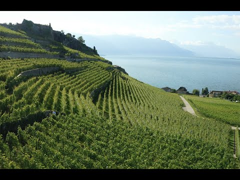
There’s clearly a slant, but you can see where it was a bit too much and so they added retaining walls to level things out.
In a place like this, you can tell what places are suitable for farming, which could be farmed with a little leveling, which are suitable for grazing, and which are just too steep for food.
They’re definitely not going to entirely level every place, but you also can’t grow food on the side of a mountain. :)
The photo of the terraced farming actually brings up an interesting point–in order to render those slopes usable for farming, terracing approximates the “flat” projection of the terrain anyways, so you end up with the same result. Buildings and any other usable structures follow the same rule: you can only build vertically, so the effective surface area is the same as the flat projection.
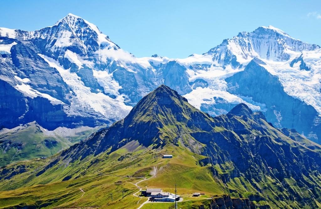
even the little bits of grass around the peaks in foreground could actually be used. I’m amazed how risky cows behaviour is regarding to the abyss, and goats somehow are just completely not afraid of heights at all and hop around on 400 meter cliffs like a walk in the park. So you can grow food (meat+milk) on mountain sides during summer
Yup, it’s why grazers are so common in mountainous areas. It’s way easier to manage goats and cows in a mountain, with some fruit, hay and wheat fields to supplement down in the valleys than it is to reshape the steep areas to make them suitable for crops.
It’s why Switzerland has it’s own type of cheese, and the flattest parts of the US are predominantly known for “lots of corn”.To be clear though, the unusable areas I referred to were more the mountains in the background, or the nearly shear cliffs in the middle ground that the shepherd is unlikely to let the (perfectly willing) goats graze on, on account of needing to be able to get the goats later. :)
There’s clearly a slant, but you can see where it was a bit too much and so they added retaining walls to level things out.
I have seen farmers work on steeper slopes (not saying it would be easy…).
I would rather guess the purpose of these retaining walls is to slow down the soil erosion.
Doubt it. Because then it becomes a question of resolution, where too high results in countries with infinite area, since ever slope, ditch, and grain of sand has to be accounted for.
That also applies to calculating the flat area though.
Luckily while the coastline number is affected, the actual area is still bounded. It’s like that infinite horn with paint paradox.
BTW are the walls of New York’s scyscrapers included in the calculation?
/s
Ok, so I know this is just a joke, but you got me thinking.
Each floor of a skyscaper with an area of x² ft, is an additional x² ft of unique space. An acre of skyscrapers, could have 20-30 times more useable square footage than an acre of farmland.
You just invented the arcology again, lol
It is a near future concept of a fully self sufficient megacity, a sort of intermediate stage towards an ecumenopolis (a planet entirely urbanized with an extreme population density). One popular example would be coruscant, the capital world of the galaxy in star wars.
So, what do you think: has a skyscraper more wall area (including the inner walls) or more floor area (counting all floors)?
That’s a fun puzzle like “how many golf balls could you fit in a 747”, but to keep in line with the spirit of the original question, I think floor space is more in line with “is the area of a space more complicated than it’s 2D outline as seen from space” than walls are.
Does that sentence make any sense rereading it? It seems very confusing.
Switzerland mentioned 🇨🇭🇨🇭💪💪
No, what for? Most of it is unusable anyway. And the less steep inclinations are in the margin of errors.
I don’t know the precise answer, but I do know this:
- Often the kind of measures that are about something vast and complex (like population for example) are really good approximations, not completely exact numbers. So maybe doesn’t matter because the number itself is not trying to be 100% accurate.
- As far as I know those measures are made from the top down view, like with airplanes or satellites, so no it would not include inclines. To include inclines in a precise way it would have to be measured each one on the spot, which is not the way that is done. There are almost no field surveyors these days, again, as far as I know. And to include inclines in an approximate way takes us to point 1 again so it wouldn’t matter much if there were a small difference.
- Why would we do that? Almost everything we use land for requires it to be horizontally flat, so we flatten it. For example, an irregular coastline doesn’t matter because we can use the crevices and irregularities to fit in more boats or ports or beaches, since the sea is horizontally flat and that is what really matter to us. But if there’s a hill with a greater area because of the steepness of it we cannot fit more houses or warehouses of streets. We have to flatten it first so we gain noting from it being inclined.
So form my point of view it would be almost as if we tried to include the sides of a ravine or gorge in the measure just because technically it is area space.
Sorry if I cannot give you an exact answer, but I wanted to comment because you raised an interesting point that made me think.
Cheers.


