

You must log in or register to comment.
Why doesn’t the larger continent simply eat the smaller ones?
Give it a few hundred million years.
Was thinking just this, hahahaha!
The “other ones” are not continents!
I’m tired of seeing all the diverse countries of Africa being lumped together as if they were homogenous.
So much land to
exploitexplore. Explore.You explore land, you expand your empire, and then it all kind of gets fuzzy and controversial after that
So much land to scramble for.
FTFY
Explore for exploitation.
All sorts of fun to be had overlying various things. I guess Africa is about 2 Russias in size.

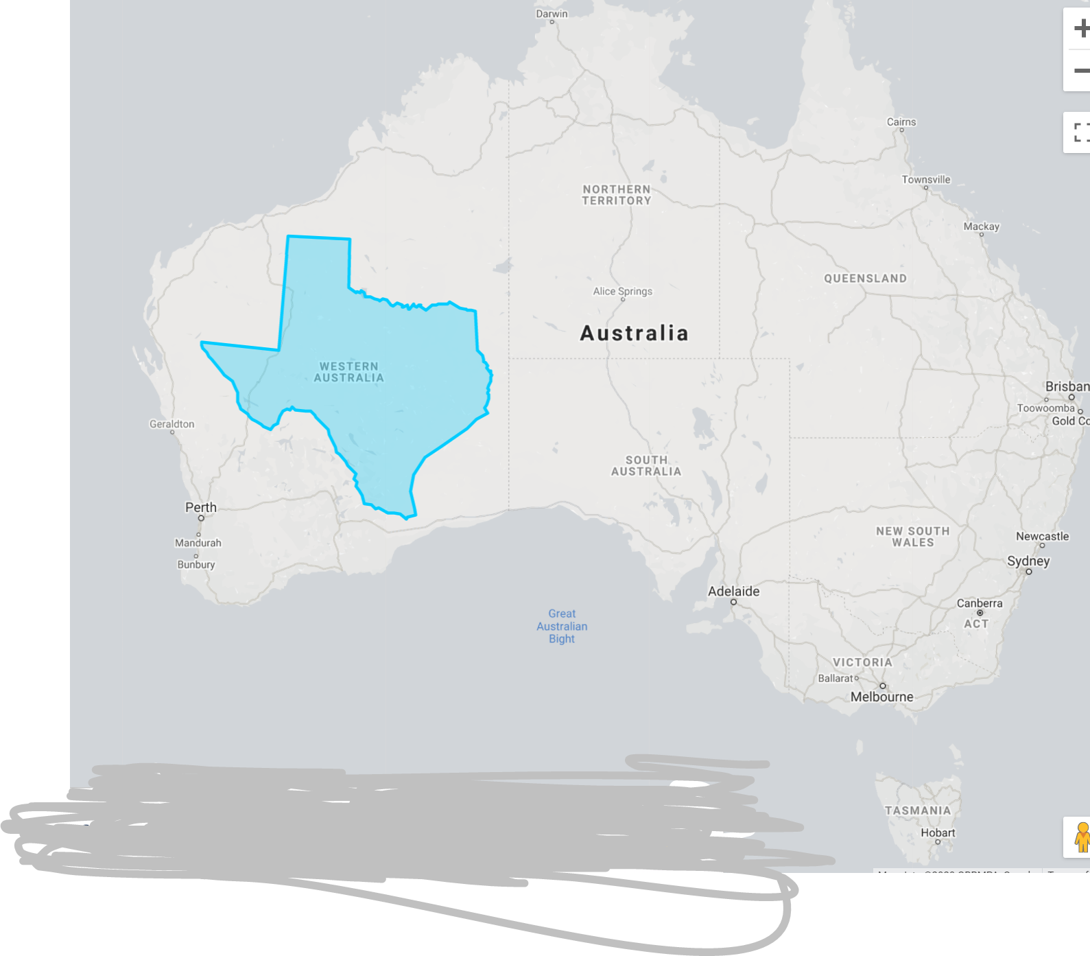
I love when I’m talking to an American and they try and tell me that I " just don’t understand how big Texas is". So then I tell them that if Texas were in Australia, it would only be the fifth largest state, sixth if you include NT (which you should, their lack of statehood while having the largest percentage population of Indigenous Australians is telling).
Wow, great map. Thanks, really shows some perspective.
Also, you should qualify that with “some” Americans. Some Americans have no concept of the US, like where the bulk of the population lives (65% live between Georgia and Boston), how empty the mid-west/west is, etc.
I’m not sure where you think I said all Americans think, or say, this. But it is a phrase that only an American would say. You aren’t going to hear many Australians say it my friend.
Big if true
Could even be true if big.
I’ve been burned before by these.
I checked it thoroughly for a smaller Africa inside it before taking it seriously.
That’s exactly what someone who would hide a small Africa inside a map of Africa would say!
The UK: “This is not what we voted for!”
Oh wow, I never realised that Japan is so long compared with Great Britain.
If you line up the latitudes you can see Japan is roughly comparable to the coasts of the US.
I’m so fucking done with maps lumping Central Europe into Eastern Europe. Like you wanna tell me that Austria, Greece, Finland are somehow not eastern but Czechia is. Or how sometimes the Baltics are not eastern but Hungary is.
In this thread: westerners telling me what I should think. Well gee, next time maybe tone down the imperialism a bit.
Finland and baltics are northern Europe, not eastern.
And yet few people would argue the same of Murmansk, mostly north of Helsinki. We really need to consider history here, as well. Specifically which side of the iron curtain they were on.
I think you might be mixing different things here, because it’s fucked up shit
Northern Europe: British isles, Scandinavia, Finland, Baltics
Nordics: Finland, Sweden, Denmark, Norway, Greenland, Iceland, Faraoe islands
Scandinavia: Sweden, Norway, Denmark
Scandinavian peninsula: Sweden, Norway, North-western Finland
Fennoscandia: Finland, Sweden, Norway, Murmansk oblast, parts of Karelia and Leningrad oblasts
And there’s more stupid definitions for differently divided areas because fuck you
Oh, well sure. If you allow them to overlap there’s no reason you can’t be in both Northern and Eastern Europe.
Perhaps some kind of North-East.
Typical Europeans: colonizing this post about Africa to make it about themselves instead. \s
I mean, I am fucking done with maps portraying Europe as a continent. It is called Eurasia, you just like feeling extra special but geographically you are not 🤪
Based
Show me your continental plate, “Europe”
I’ve never heard anyone claim the Baltics are not Eastern Europe. Then again, I’m on a different continent.
As for the rest, it’s all down to which side they were on/put in during the Cold War.
Austria is literally lumped into “Eastern Europe” on this map lol
No, it’s not. That’s why it has its own specific label…
I don’t understand - Greece, EE and Austria are all clearly overlaid in top of each other in the same space. It makes no sense
They labelled those parts of the connected landmass with those separate labels so people wouldn’t complain that some parts didn’t belong to the culturally arbitrary grouping.
The point of the map is to demonstrate that Africa is larger than all of those geopolitically relevant areas, and those connected bits fit into the space so it was included. Don’t think too much about it.
Not in, like, the “there’s nothing there” way, but in the “there’s no substantive economic, social or geographic reasons to treat it as a cohesive region” way
I mean there is, its the old Soviet block countries, its just not really relevant anymore.
that’s pretty angry
No wonder we never found kony
It took me way to long to realize what I was looking at…


