
Yup, was a Garmin. Part of me has been a little worried cause i can’t find my way anywhere without GPS anymore, and Google has been getting shittier every day.
Hell, I remember the first time I used maps on a computer to plan and print a route, and the first time I could do it online with MapQuest.
Those were moments that the Internet really felt like the future.
I used to tape maps to the gas tank of my motorcycle on trips.
Then mapquest became useful and I taped printed directions. Made it a lot easier.
Then I got a Garmin waterproof, handlebar mounted GPS and it was glorious, though you had to buy map updates every couple years.
Eventually phones were actually able to be used for directions and I kept a phone connected to a homemade battery pack in my jacket pocket, with an earbud under my helmet, so I just listened to directions and music.
Finally got a phone connected to a handlebar mount, plugged into the bike power, with a Bluetooth headset built into the helmet. Probably the least safe of the options, but I can listen to podcasts, audiobooks, music and see the maps while it directs me with audio, just like a car display would.
I rode from the UK to northern Italy with nothing but an early hiking go’s unit that had no map. Just an arrow pointing to Torino. The trip over the Alps was very random.
I’m still not sure how i found anything before gps was a thing. I remember getting my licence and my first trip with a friend. He printed out like 20 pages of google maps. He sat next to me and went through it like a person wo went mad on the nautilus. Halfway through it, he threw it all on the backseat and only kept the last page and said: "we’re looking for some place that sounds like hitler and then 15 min later we go left and there is a house with a dragon in the yard.
We never took a wrong turn on the whole trip. Same at work, i would get a bad printout of a city block where i wasn’t even sure where it was. And somehow after driving around in circles for a bit i would always magically find it.
Didn’t mapquest get sued for routing people through a dangerous neighborhood? Then they started putting a disclaimer?
It tells you which direction something is in, but can’t help plot a route to get there.
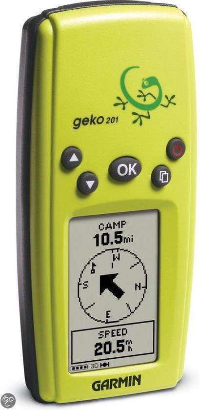
I still use my Garmin Geko even now. Useful as a basic device recording a track I can geocode photos with, and runs for days on two AAA batteries. In a pinch you can reverse a track and go back the way you came too 😅
That’s such a good idea. My camera has to pair with my phone to get GPS readout and it’s a nightmare app. Going to look into this
Openstreetmap has a load of tools to help with this, as we used to use this technique for surveying.
For example, JOSM can geolocate photos against a GPX file, and display them over your map.
That’s even better. Thank you
Nice device!
I still remember printing out google maps directions, then missing one turn and then being completely lost.
The number of times I had to stop and recalibrate with the paper map was high!
I used to geocache this way because I couldn’t afford a GPS. Finding caches took some time!
Yep. Seemed pretty shiny compared to printing off directions from MapQuest. Then we figured out how to customize the voice, and it was shenanigans from there.
Man, TomTom had some kickass ones. Vader was on mine for too long.
Internal thought process: “psh, it’s not just over-35’s who remember the dawn of GPS, I’m only… thirty… six…” 😩
I don’t have deeply shocking memories about using GPS for the first time, it was just this gadget my dad got for road trips so we didn’t have to deal with an atlas. However, I still remember being a passenger in a moving car using my first smartphone, watching our progress on Google Maps and feeling like I had gained the ability to see around corners. Technological progress seemed unambiguously positive and my phone just kept getting more useful.
Alternate question: do any of you (maybe a bit older than 35) remember the last time you bought an updated paper map for your area, or one for a road trip? They used to be at most checkout lanes in many stores.
I can already hear the “maps on paper? How could you find anything?”
Maybe five years ago?
I like having paper maps in the “oh shit” bag
No, because if I need information I stop at information places at the border and get a map for free. Sometimes you can get whole guidebooks full of maps and directions and interpretive information for free. I picked up maps or guidebooks multiple times this year.
I do still use my city’s paper bike route maps, although they’re free. I rarely use them to get to a specific place, though, just for planning where I can make a contiguous loop I haven’t done before.
I bought a couple usgs maps of the local mountains about 8 years ago, but that was the last time. Used to buy the map book for Michigan every few years when I lived there. Had pretty detailed prints of all the roads, waterways, state lands, and even marked hiking trails. Great for finding streams for fishing and places to camp. But now printed maps seem hard to find. Local gas stations don’t have them, and I’ve noticed that rest stops on the highway don’t give them out anymore either. Used to hit rest stops in every state I drove through when traveling to get new ones for the glove box.
Paper maps are still available and free in (most?) welcome centers along US interstate highways. My mom had me stop and get her new maps every year whenever I went somewhere. She passed 5 years ago, and I still have the urge to pick up a map when I’m roadtripping.
I remember how tedious using maps to get anywhere was.
Last week I traveled through some rural desert backroads and Apple Maps got me there no problem, but it had taken me on an indirect route. As I was driving I discovered that it was because a number of the roads were completely closed. If I had been using maps I would have had to stop and figure out the detours on my own.

Garmin nuvi 250, and then shortly after that a Garmin Nuvi 500, which I still use almost every day when I drive.
Almost 20 years old.

Hertz rent a car on a business trip. It was this little box with a yellow display that would ding when it was time to turn. I thought it was so cool!
In 2001, I rented a van in Japan. Digital mapping is essential for Japan, because most streets have no names, and house numbering is almost completely random, often based on the year they were built rather than any linear sequence.
It was incredible to me to be able to punch in a destination and see the map. At the time, I don’t think it could speak the directions to you. And you could search for nearby restaurants and gas stations too!
I couldn’t tell you the specifics, but back in the 1990’s, we had GPS devices that just had an LCD read-out of your latitude and longitude, so you could find your position on a paper map. They were on the market as survey devices, but were also useful for wilderness travelers.
It’s hard to recall exact dates, because the devices developed incrementally, and navigation mode on Google Maps didn’t spring into existence ask at once.
Yes. I remember seeing them advertised on a trip to Japan and not fully understanding how they even worked. It really seemed like the future. It was a few years before they were available here and prices came down enough to use it. My first trip was navigating home from Fry’s
I do, the GPS maps was of course outdated, and brought us to the most random mud trail in the area.
It had potential, but definitely a lot of things to improve.
Yes. I was prepared though, I had directions from Mapquest printed out and ready to go in case it messed up. I was using an early-gen Garmin GPS that was just a GPS. It did mess up quite a bit, and I had to take it inside, plug it into my computer to update maps. It also could only hold so much, so I had to limit the maps I had available to just my city.
I first used MapQuest in HS (2000) and it took us so far out of the way just to use a main road.